


 Art & Design
 Auto & Vehicles
 Beauty
 Business
 Education
 Entertainment
 Finance
 Food & Drink
 Health & Fitness
 House & Home
 Libraries & Demo
 Lifestyle
 Maps & Navigation
 Medical
 Music & Audio
 Parenting
 Personalization
 Photography
 Productivity
 Shopping
 Social
 Sports
 Tools
Tools Travel & Local
 Video Players
 Weather
 Family


 PeakVisor
OS :
Version :4.40
Size :246.32Mb
Updated :Nov 5,2022
Developer :Routes Software SRL
 Ask AI
You can ask
the AI some questions about the app
Here are three topics that users may discuss about the PeakVisor app, turned into questions for you:
1. How do you find the accuracy of the app's sunrise and sunset predictions?
2. Have you noticed any improvements in your outdoor activities or navigation since using PeakVisor?
3. What features of the app do you find most useful for planning your outdoor adventures?
 Ask AI
Pros and Cons from users' feedback
I'd be happy to help you with that! After analyzing the user reviews on the Apple App Store, here are three pros and three cons of the PeakVisor app:
Pros:
1. "Accurate and reliable compass readings, even in challenging outdoor environments."
2. "User-friendly interface makes it easy to navigate and find your way."
3. "Innovative features like augmented reality and 3D visualization enhance navigation experience."
Cons:
1. "Occasional glitches and crashes can be frustrating and disrupt navigation."
2. "Limited offline functionality can be a concern for users without internet access."
3. "Some users find the app's subscription model and in-app purchases confusing and expensive."
Please note that these are general summaries based on user reviews and may not reflect your personal experience with the app. If
App
Downloads
<
>
App
Survey
-
How much traffic the app consumes Does it affect the experience?
-
Application interactivity Does it affect the experience?
-
Why do you uninstall an app?
-
Where do you get the new APP
Description
PeakVisor will make you a superhero of outdoor navigation by putting state-of-the-art 3D maps and mountain identification magic wand in your hand.
"PeakVisor uses your iPhone's camera and augmented reality (AR) technology to display names and elevation of nearby peaks. The information will appear on your phone like magic." - App Store, Take the Trail Less Traveled
Key Steps to Becoming a Superhero:
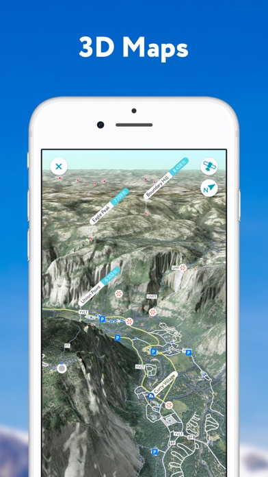
● 3D Map your Hike
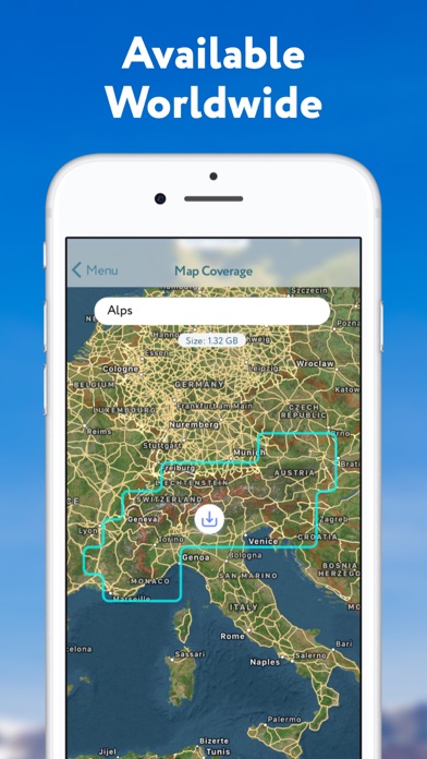
Get your topo maps of the future. The cutting-edge technology with high-precision terrain modeling allows simple yet effective insight into the landscape of the mountains. It is the most convenient way to explore a mountainous area, its trails, summits, passes, viewpoints, and even parking areas.
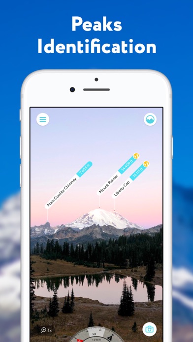
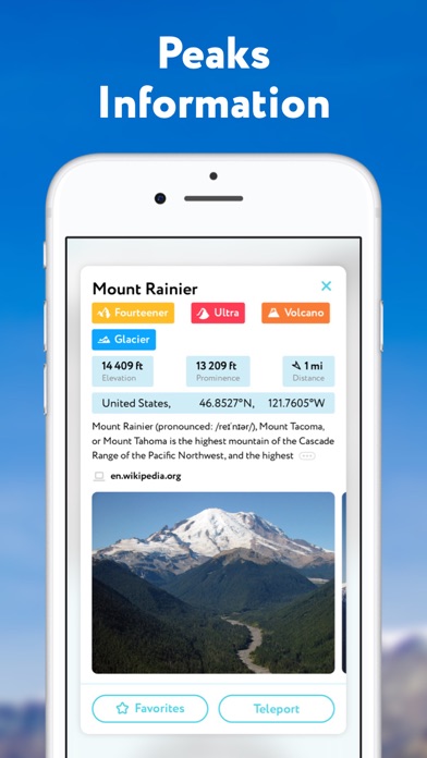
● Identify Mountains hundreds of miles away
Identify more than a million mountains & hills all over the world and get a detailed profile for each of them, including altitude, topographic prominence, mountain range, what national parks or reserves it may belong to, as well as photos and additional Wikipedia articles.
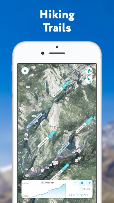
● Plan Hiking Routes
A vast network of worldwide hiking trails and walking pathways included in PeakVisor’s 3D Maps will help you compose a hiking route which includes evaluating the distance you can expect to hike as well as a route’s elevation profile and estimated time for completion.
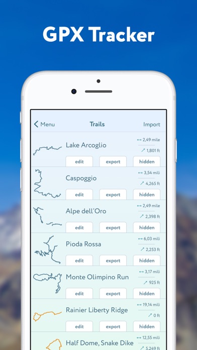
● Use GPS Tracker to share your epic adventures
Track your outdoor adventures, see your stats such as elevation gain and walking distance as well as your path in the 3D world. The app also allows you to import and export GPX files.
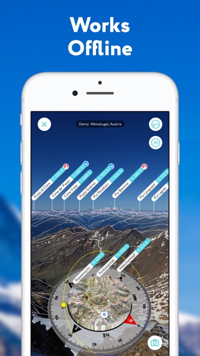
● Everything works Offline
All the data is downloadable and ready for off the grid journeys.
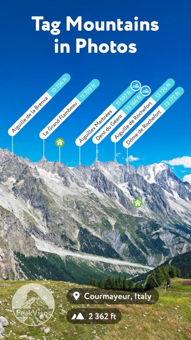
● Identify Mountains in Photos
If you have photos from previous hikes that you have not taken through the app, you can still find out what peaks you have been by importing your images into the PeakVisor app.
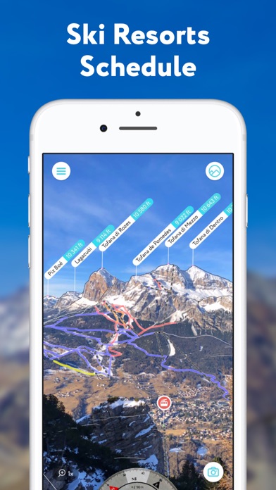
● Ski and Snowboard when Winter Comes
PeakVisor is extremely useful for any kind of winter sports in the mountains. Topographic 3D Maps allow for a better understanding of the terrain and provide detailed information about mountain lifts, ski runs, and popular backcountry skiing opportunities. No matter where you go and how hard you challenge yourself this winter, PeakVisor will be the perfect booster for your outdoor adventures.
PeakVisor is the Swiss army knife of outdoor adventure and will soon be indispensable to all your future hiking needs. Just keep it in your backpack and you'll get value from it every time you’re on the trail!
PeakVisor PRO is a premium subscription that allows you to use the app without any limitations. By subscribing to PeakVisor PRO you make it possible for us to focus on ever-excelling the app. PeakVisor PRO is available as a monthly or an annual subscription.
If you choose to get PeakVisor PRO, the payment will be charged to your Apple ID account once you confirm your purchase. The subscription automatically renews unless it is canceled at least 24 hours before the end of the current period. Your account will be charged for renewal within 24 hours before the end of the current period. You can manage and cancel your subscriptions through the App Store account settings after purchase. Any unused portion of a free trial period, if offered, will be forfeited when the user purchases a subscription to the publication, where applicable. You may find more details in our Terms and Privacy Policy available by the link => https://peakvisor.com/en/terms.html
If you have any questions or just feel like talking about mountains, please contact us at peakvisor@routes.tips
{{descriptionMoreText}}
Comments (4)
{{commentText.length}}/{{maxCommentText}}
{{commentError}}{{commentUserError}}
-
{{comment.commentUser.substring(0, 1)}}By {{comment.commentUser}}{{comment.commentDateString}}
-
CBy Clint Arthemis GolubMar 4,2019
-
RBy Robbo MonAug 14,2019
-
tBy tommmmmmmmmmmgggggJul 27,2020
-
JBy Jrobert.in.WiltonJan 30,2020


Category Top
apps
- Google Play
- App Store


More Apps


