


 Art & Design
 Auto & Vehicles
 Beauty
 Business
 Education
 Entertainment
 Finance
 Food & Drink
 Health & Fitness
 House & Home
 Libraries & Demo
 Lifestyle
 Maps & Navigation
 Medical
 Music & Audio
 Parenting
 Personalization
 Photography
 Productivity
 Shopping
 Social
 Sports
 Tools
Tools Travel & Local
 Video Players
 Weather
 Family


OS :
Version :11.1.4
Size :141.23Mb
Updated :Nov 7,2022
Developer :Atlas Guides DE, Inc.
 Ask AI
You can ask
the AI some questions about the app
Based on online discussions about the Farout Guides app, here are three topics and corresponding questions:
Topic 1: User Experience
What do you think about the app's user interface and navigation?
Topic 2: Travel Planning
How do you usually plan your trips, and do you think Farout Guides can improve your planning process?
Topic 3: Destination Selection
Which types of destinations or routes interest you most, and do you prefer the app's suggested itineraries or create your own?
 Ask AI
Pros and Cons from users' feedback
I'd be happy to help you with that! After analyzing the user reviews on the Apple App Store, here are three pros and three cons of the Farout Guides app:
Pros:
1. "Accurate and detailed guides make traveling a breeze, even in unfamiliar areas."
2. "Offline maps and navigation work seamlessly, no need for constant internet."
3. "Community-driven content ensures up-to-date information and helpful tips from fellow travelers."
Cons:
1. "Occasional glitches and crashes can be frustrating, especially during critical moments."
2. "Limited customization options for personalizing the app to individual preferences."
3. "Some users report difficulty in finding specific destinations or navigating complex routes."
Please let me know if you'd like me to elaborate on any of these points or if you have any further questions!
App
Downloads
<
>


App
Survey
-
The degree of memory and power consumption Does it affect the experience?
-
Where do you get the new APP
-
How much traffic the app consumes Does it affect the experience?
-
Ease of use of the application Does it affect the experience?
Description
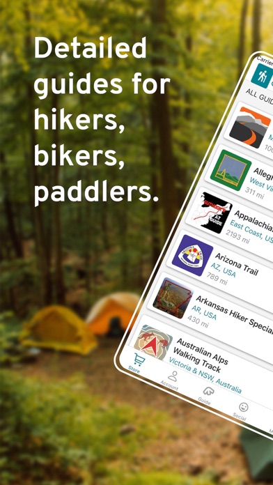
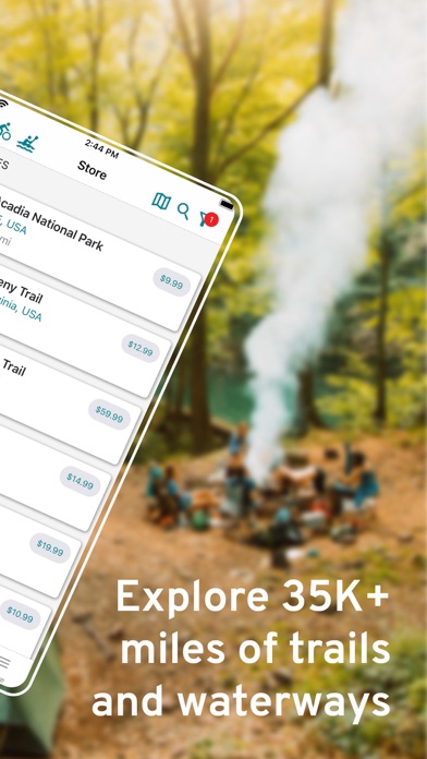
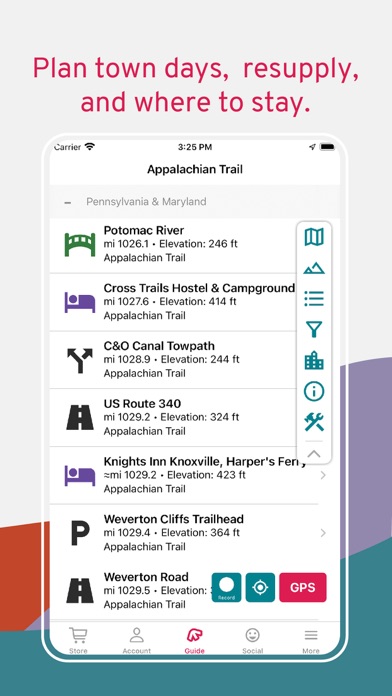
FarOut (formerly Guthook Guides) is the most popular app for long-distance hiking, biking, and paddling.
Explore 100+ trail guides around the world while staying connected to your friends & family back home with our Check-in feature.
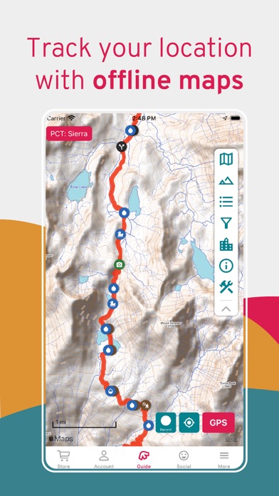
WORKS COMPLETELY OFFLINE
Each guide works completely offline, even in airplane mode. It uses your mobile device's internal GPS to display your location and guide you along the trail no matter where you are. Whether you go on a day hike, section hike, or thru hike, FarOut will help you find your way. The majority of thru-hikers use our app on America's Triple Crown trails which include the Appalachian Trail, Pacific Crest Trail, and Continental Divide Trail.
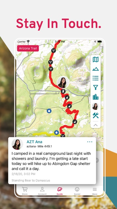
FAMILY AND FRIENDS CAN FOLLOW YOUR ADVENTURE
Invite friends and family to follow you on your adventure. Drop Check-ins along the trail and leave updates to let your followers know you're safe. Adjust your privacy settings, approve followers, find friends to follow, and manage check-ins in the Social menu.
TRUSTED DATA
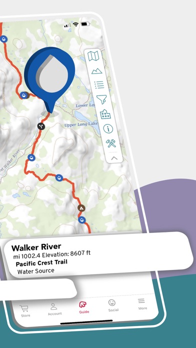
FarOut has your adventure covered with detailed maps showing your exact GPS location, detailed trails, and useful waypoints. All of our data is collected by trusted individuals and partners, and is kept up to date.
KEY FEATURES
-Works offline: no data or internet required after initial setup
-Detailed waypoints and town resupply guides
-Keep your friends and family up to date by checking in and sharing your location
-Detailed offline maps including GPS location, detailed routes, and waypoints
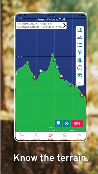
-Elevation profile view to see when your next big climb is
-Create your own custom route and waypoints to plan your trip
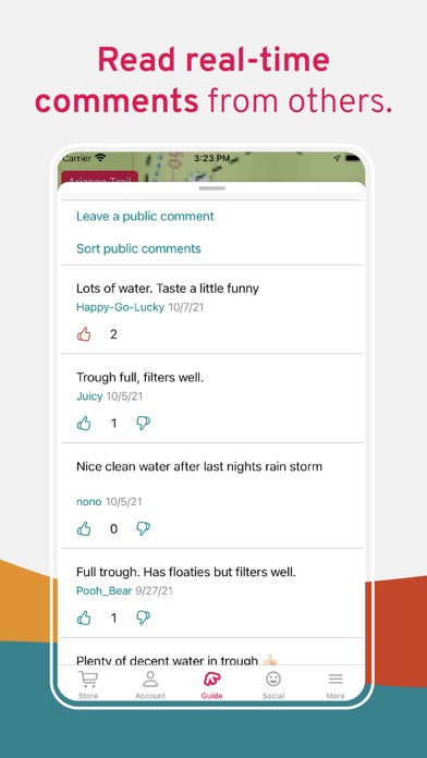
-Stay informed by reading real-time waypoint comments from other hikers, bikers, and paddlers
DETAILED WAYPOINTS AND TOWN GUIDES
-Waypoints include: water sources, shelters, campsites, road crossings, trailheads, junctions, viewpoints, peaks, parking, and many others
-Town guides include: accommodation, restaurants, resupply, laundry, post offices, shops, historical sites, and more
UNITED STATES NATIONAL SCENIC TRAILS:
Appalachian Trail
Arizona Trail
Continental Divide Trail
Florida Trail
Ice Age Trail
New England Trail
Pacific Crest Trail
Pacific Northwest Trail
UNITED STATES REGIONAL TRAILS:
Allegheny Trail
Benton MacKaye Trail
Buckeye Trail
Buffalo River Trail
The Colorado Trail
Eagle Rock Loop
Grafton Loop Trail
International Appalachian Trail
John Muir Trail
The Long Trail
Lost Coast Trail
Mid State Trail
Monadnock-Sunapee Greenway
Mount Whitney Trail
Ocean to Lake Trail
Ouachita Trail
Ozark Highlands Trail
Pinhoti Trail
Tahoe Rim Trail
Tully Trail
Wonderland Trail
UNITED STATES TRAIL NETWORKS:
Acadia National Park
Baxter State Park
Camden Hills
Camel's
Cutler Coast
Donnell Pond Public Reserved Land
Glastenbury & Bald Mountain
Gulf Hagas
Killington & Pico
Maine High Peaks
Mahoosuc Range
Monadnock State Park
Mount Mansfield
Mount Sunapee
Pillsbury State Park
Pinnacle Mountain State Park
San Jacinto Mountains
Stratton Mountain
Tumbledown & Little Jackson
White Mountain National Forest
Worcester Range
CANADA:
Great Divide Trail
International Appalachian Trail
NEW ZEALAND:
Te Araroa
Greenstone & Caples Track
Kepler Track
Milford Track
Routeburn Track
AUSTRALIA HIKING:
Australian Alps Walking Track
Bibbulmun Track
Cape to Cape
George Bass Coastal Walk
Heysen Trail
Larapinta Trail
Overland Track
South Coast and Port Davey Track
Three Capes Track
Walk the Yorke
Wilson's Promontory Grand Circuit
AUSTRALIA CYCLING:
Dozens of long-distance routes and Rails to Trails routes across the entire country
UK & EUROPE:
Camino Frances / Camino de Santiago
Camino Finisterre
Camino del Norte
Croatian Long Distance Trail
Coast to Coast, Wainwright's
Cotswold Way
Hadrian's Wall Path
The Ridgeway
South Downs Way
Tour du Mont Blanc
West Highland Way
MIDDLE EAST:
Israel National Trail
Jordan Trail
SOUTH AMERICA:
Torres del Paine, O & W Circuits (Chile)
SUPPORT
If you have any questions, email us at support@faroutguides.com
{{descriptionMoreText}}
Comments (2)
{{commentText.length}}/{{maxCommentText}}
{{commentError}}{{commentUserError}}
-
{{comment.commentUser.substring(0, 1)}}By {{comment.commentUser}}{{comment.commentDateString}}
-
mBy michtanger (Pickup)Jun 2,2022
-
SBy Silver SupertrampOct 17,2019
Category Top
apps
- Google Play
- App Store


More Apps


