


 Art & Design
 Auto & Vehicles
 Beauty
 Business
 Education
 Entertainment
 Finance
 Food & Drink
 Health & Fitness
 House & Home
 Libraries & Demo
 Lifestyle
 Maps & Navigation
 Medical
 Music & Audio
 Parenting
 Personalization
 Photography
 Productivity
 Shopping
 Social
 Sports
 Tools
Tools Travel & Local
 Video Players
 Weather
 Family


 North Carolina Pocket Maps
OS :
Version :5.2
Size :105.33Mb
Updated :Oct 7,2022
Developer :Alex Gugel
 Ask AI
You can ask
the AI some questions about the app
Based on online discussions about the North Carolina Pocket Maps app, here are three topics and questions:
Topic 1: Navigation
What features does the app offer to help users navigate the state of North Carolina?
Topic 2: Offline Access
Can users access the app's maps and features offline, without an internet connection?
Topic 3: Content Updates
How often does the app receive new content and updates to reflect changes in North Carolina's roads, attractions, and points of interest?
 Ask AI
Pros and Cons from users' feedback
Based on the users' reviews, here are three pros and cons for the North Carolina Pocket Maps app:
**Pros:**
1. Accurate maps and directions provide users with a seamless navigation experience.
2. Offline access allows users to explore without relying on cellular data or WiFi.
3. User-friendly interface makes it easy to find places and plan routes.
**Cons:**
1. Some users experienced lag or delays when searching for specific locations.
2. Minor inaccuracies in mapping data have been reported by a few users.
3. Limited information on certain businesses or attractions is a disappointment.
Note: The reviews are generally positive, but these points highlight some potential areas of improvement.
App
Downloads
<
>

App
Survey
-
Does the frequency of application notifications affect the experience?
-
Does the feedback of the application affect the experience?
-
What is the number of APPs on your phone?
-
How much traffic the app consumes Does it affect the experience?
Description
Be prepared! Plan your next trip to one of the great North Carolina parks. Download maps and guides before you venture into the Wi-Fi free wilderness.
Discover
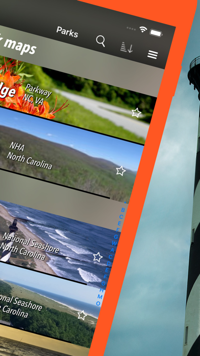
- 70+ national parks, state parks, monuments, forests
- 50+ neatly folded maps by the National Park Service, Bureau of Land Management, United States Forest Services, and other agencies.
- Motor Vehicle Use Maps (MVUM), Motor Vehicle Travel Maps (MVTM) and visitor maps for California national forests.
- 600+ campgrounds and campsites
- 900+ trails and trailheads
- 61,000+ points of interests
Plan
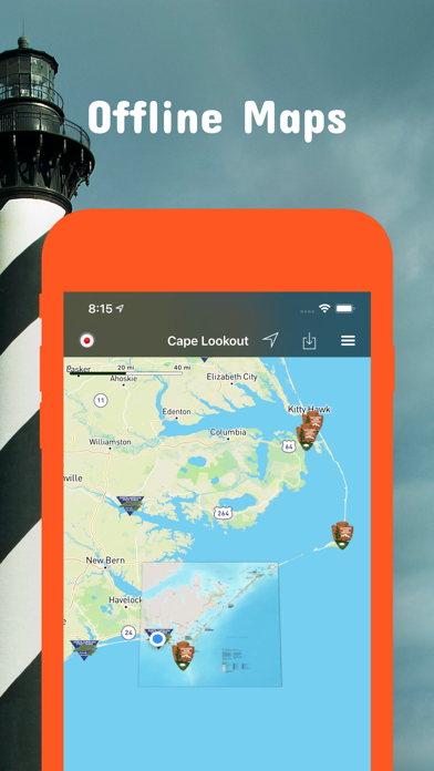
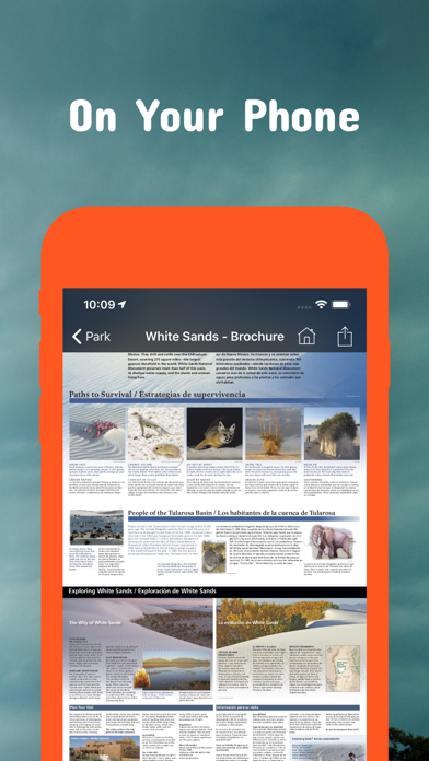
- Download maps, park brochures, and newspapers. These downloads are ready when you are offline and off the grid in the great outdoors.
- Download arbitrary map sections as offline packs.
- Photo galleries, panorama views.
- Share links to parks and maps with friends
Have fun
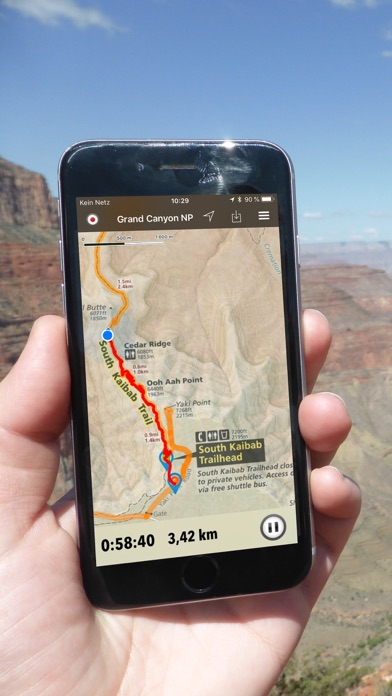
- GPS and GPX support: record your hikes, import GPX routes, tracks and waypoints for your hiking trails.
- Detailed national park information: alerts, news, visitor centers, campgrounds, driving directions, weather.
- Open your favorite maps app to get a route to the selected park.
- Current weather conditions, easy access to multi-day forecasts, sunrise and sunset times.
- Push notifications for park alerts, park news, weather warnings
So download maps and guides for:
Blue Ridge
Cape Hatteras
Cape Lookout
Carolina Beach
Chimney Rock
Croatan
Elk Knob
Fort Macon
Fort Raleigh
Gorges
Grandfather Mountain
Great Smoky Mountains
Guilford Courthouse
Hanging Rock
Nantahala
Pisgah
South Mountains
Stone Mountain
Uwharrie
Wright Brothers
There are additional useful information and brochures for:
Appalachian, Carl Sandburg Home, Carvers Creek, Cliffs of the Neuse, Crowders Mountain, Dismal Swamp, Eno River, Falls Lake, Fort Fisher, Goose Creek, Gullah/Geechee, Hammocks Beach, Lumber River, Moores Creek, Overmountain Victory, Pettigrew
- FULL ACCESS is available for a for $3.49/three month (after a free 3-days trial period) or $2.49/two months or $7.49/year. You can subscribe and pay through your iTunes account. The account will be charged for renewal within 24-hours prior to the end of the current period, and identify the cost of the renewal. Your subscription will automatically renew unless canceled at least 24 hours before the end of the current period. Auto-renew can be turned off anytime by going to your Account Settings in iTunes after purchase.
- Continued use of GPS running in the background can dramatically decrease battery life.
LEGAL
Terms of Use: https://www.icoat.de/pocketmaps/terms
Privacy Policy: https://www.icoat.de/pocketmaps/privacy
{{descriptionMoreText}}
Comments (0)
{{commentText.length}}/{{maxCommentText}}
{{commentError}}{{commentUserError}}
-
{{comment.commentUser.substring(0, 1)}}By {{comment.commentUser}}{{comment.commentDateString}}
Developer apps

Category Top
apps
- Google Play
- App Store


More Apps


