


 Art & Design
 Auto & Vehicles
 Beauty
 Business
 Education
 Entertainment
 Finance
 Food & Drink
 Health & Fitness
 House & Home
 Libraries & Demo
 Lifestyle
 Maps & Navigation
 Medical
 Music & Audio
 Parenting
 Personalization
 Photography
 Productivity
 Shopping
 Social
 Sports
 Tools
Tools Travel & Local
 Video Players
 Weather
 Family


 San Francisco Metro from Zuti
OS :
Version :4.0
Size :15.67Mb
Updated :Oct 14,2017
Developer :Visual IT Ltd
 Ask AI
You can ask
the AI some questions about the app
Here are three topics related to the San Francisco Metro app, turned into questions:
1. How easy is it to navigate train stations and routes using the app's layout and mapping features?
2. Are the real-time updates and schedules provided by the app accurate and helpful for planning your daily commute?
3. Can you customize the app to display your favorite routes or stops, and save frequently used locations for easy access?
 Ask AI
Pros and Cons from users' feedback
Based on the users' reviews of the "San Francisco Metro from Zuti" app, here are three pros and cons in English, limited to 15 words each:
**Pros:**
1. Accurate and easy-to-use map navigation helps users navigate SF Muni quickly and efficiently.
2. Real-time route updates and alerts ensure a smooth travel experience, even on busy days.
3. Comprehensive transit information allows users to plan routes and track their journeys seamlessly.
**Cons:**
1. Limited functionality compared to other transit apps, with few customization options.
2. Some users report issues with slow loading times and occasional app crashes.
3. No offline mode available, requiring a stable internet connection for navigation.
App
Downloads
<
>


App
Survey
-
Why do you uninstall an app?
-
How much time do you spend on app applications every day?
-
Application interactivity Does it affect the experience?
-
Do you think the payment of application features affects the experience?
Description
This app is great for getting around San Francisco using the BART, Muni Metro, Cable Car and Historic Streetcar services. It contains a beautiful map, some unique features and is great for visitors or locals.
● KEY FEATURES ●
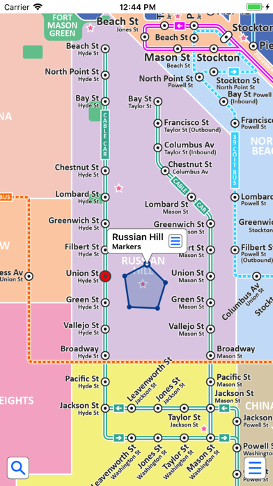
● Colourful clear map with major geographical features and places of interest.
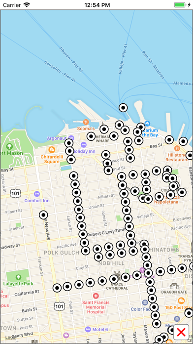
● View the map, look up places of interest, plan your journey, etc all without an internet connection.
● Unique "Travel Explorer" feature provides a view of travel times and distances to any location on the map.
● Detailed route itinerary with step by step instructions.
● Save and recall favourite and recent journeys.
● Easily locate your nearest transport stop.
● Take me home feature.
● Online street map integration (internet connection required).
● OVERVIEW ● The San Francisco Metro - Map and route planner by Zuti makes it easy to travel in and around San Francisco using the BART, Muni Metro, Cable Car and Historic Streetcar services. Also included are the AirBart shuttle bus, AC Transit Bus, Ferry services, PresidiGo Around the Park shuttle and Downtown bus services. The application contains a professionally drawn map and route planner with many unique features. The map provides a simple and colourful view of the city transport services with the ability to switch to an online street map view when an internet connection is available. This provides the best of both worlds, the transport map and route planning anytime, anywhere and online street maps and search when an internet connection is available.
● TRAVEL EXPLORER ● The unique travel explorer feature provides a view of travel times using transport or on foot and distances in miles or kilometres from any location on the map. This is helpful for getting a sense of scale and connectivity of the transport system and can provide some interesting results. For example is it quicker to use the Muni to go from Traval St & Sunset Blvd to Deboce Ave & Church St or is it quicker on foot? (Hint, the quickest route will keep you fitter). No other application makes it so easy to get around and allow you to make travel decisions based on actual distances and estimated travel times on foot.
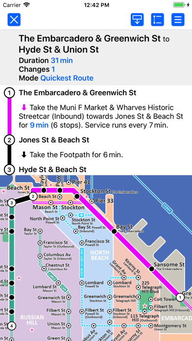
● ROUTING ● The application does not require an internet connection and will always be available to display a clear and detailed view of the city transport systems, plus list and animate the optimum route for your journey. Provides the fastest route calculations of any mobile routing application (virtually instantaneous) using actual published journey times with the ability to select the quickest route or the route with the least changes.
Comprehensive details of your planned route are provided, including “direction”, “towards” and “service frequency” information (not available on any other offline journey planner) for example “Take the Muni N Judah line (Outbound) towards Judah St & La Playa St for 25 mins (21 stops). Service runs every 10 minutes” which is essential when finding the correct platform and direction. Also given are alternatives for each leg of the journey.
● NO INTERNET CONNECTION REQUIRED ● The map and routing do not require an internet connection and you will not be charged data connection fees. This means the application saves on battery power and runs perfectly underground, on an aeroplane, etc. For international visitors to a city who have data roaming turned off this is an ideal solution.
● MORE MAPS ● This map is one in a series of Zuti worldwide city maps, if you like this product you may also enjoy some of our other offerings, please visit www.zuti.co.uk for further information.
{{descriptionMoreText}}
Comments (0)
{{commentText.length}}/{{maxCommentText}}
{{commentError}}{{commentUserError}}
-
{{comment.commentUser.substring(0, 1)}}By {{comment.commentUser}}{{comment.commentDateString}}
Category Top
apps
- Google Play
- App Store


More Apps


