


 Art & Design
 Auto & Vehicles
 Beauty
 Business
 Education
 Entertainment
 Finance
 Food & Drink
 Health & Fitness
 House & Home
 Libraries & Demo
 Maps & Navigation
 Medical
 Music & Audio
 Parenting
 Personalization
 Photography
 Productivity
 Shopping
 Social
 Sports
 Tools
Tools Travel & Local
 Video Players
 Weather
 Family


 Sail Expert: Sailing App
OS :
Version :5.1.210
Size :
Updated :Sep 16,2022
Developer :Poterion
 Ask AI
You can ask
the AI some questions about the app
Here are three topics that users might discuss online about the Logbook app, turned into questions:
1. What is your favorite feature of the Logbook app that makes it stand out from other note-taking apps?
2. How do you use the tagging system in Logbook to organize your notes and make them easily searchable?
3. Have you experienced any difficulties in syncing your Logbook data across multiple devices, such as Android and iOS?
 Ask AI
App
Downloads
<
>


App
Survey
-
What is the number of APPs on your phone?
-
Application interactivity Does it affect the experience?
-
Why do you uninstall an app?
-
What exercise apps have you heard of or used?
Description
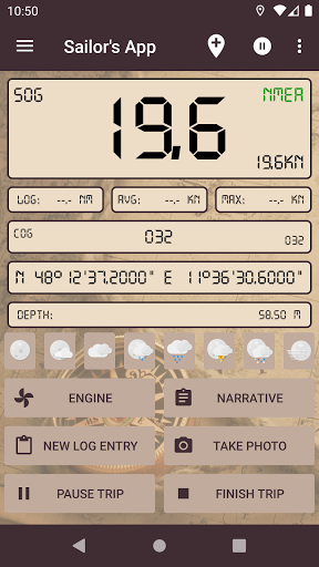
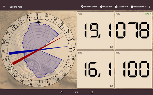
The Sailing Expert application, a swiss knife for sailors, supports navigation, regatta, helps sailors to keep their logbook, shows weather forecast, keep maintenance log for different boats and more.
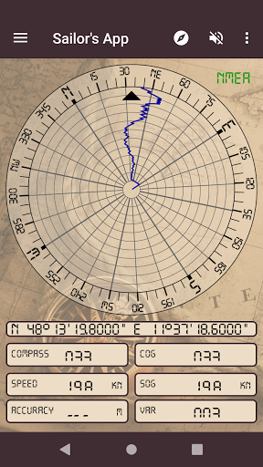
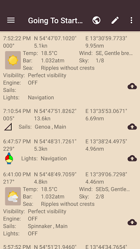
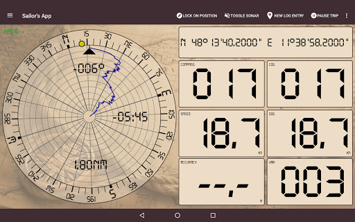
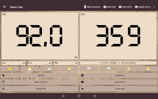
The device's sensors are used to fill the log (location, COG, SOG, temperature, pressure).
If a WiFi NMEA provider is available over WiFi the boat sensors will be used instead. Both TCP and UDP is supported.
Please see https://sail.expert/permissions for how this app uses permissions.
• GGA, GLL, GNS, RMC - Positioning
• HDG, HDM, HDT, VHW - Heading
• VBW, VHW, VTG - Course, speed
• VLW - Trip log
• DBT, DBP - Depth
• RPM - Engine revolutions
• MDA, MHU, MMB, MTA, MTW, MWD, MWV, VWR, VWT - Meteo/weather
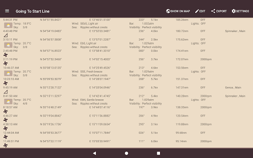
The application will tell you the target course or alert if you are off course, calculate the remaining distance and estimated time of arrival (ETA).
• Routes: while sailing you can use routes to navigate
• Target: fix a concrete bearing or target point of interest (POI) you want to sail to
• Passage: the application help you plan a passage using a distance-time graph method
• Startline: on regattas the application helps you to cross the startline on time and with optimal speed
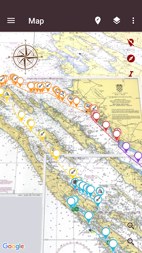
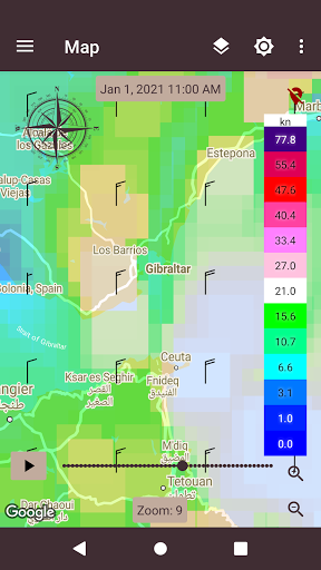
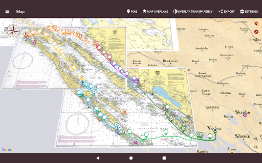
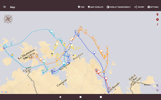
• Map data from OpenSeaMap project or NOAA RNC are available in the application for offline use
• Custom map servers can be used with this application (e.g. OpenStreet maps)
• Local MBTiles files can be imported
• Scanned maps can be imported, calibrated and setup up as a map source
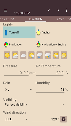
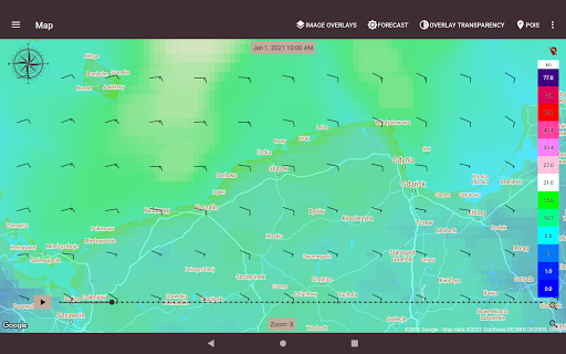
Global weather forecasts (NOMADS GFS, DWD ICON Global and selected locations) can be downloaded to the app and used during your trip.
• Trips can be prepared ahead with support of simple check-in and check-out for boat transfer
• Trips or their parts can be exported to CSV, GPX and PDF directly from the app
• Logged data can optionally be synchronized with https://sail.expert
• Trip can be share between devices using P2P connection over WiFi
• While on anchor the app monitors your location and alarms you if drifted outside the set area. Such area can be configured as a location and radius or a set of points (polygon). A second device can be setup to monitor anchor alarm remotely.
• Simple expression can be set as alarms on different instruments
• Optional contact suggestion feature when adding/editing people in the app (needs permission to read your contacts)
• PDF export
• Passage planner (distance-time graph)
• Manual position fix
• Audible speed coach
• Maintenance log for boats
• Anchor alarm
• P2P data transfer between devices
• In-app help (only EN)
• Backup/restore
• NMEA over WiFi
• Weather forecast
• Wind profile
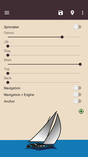
• Nautical map overlays
• Navigation
• OpenSea Maps
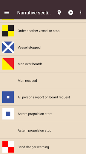
• Man Over Board
• Starting line
• Units (metric, imperial, ...)
• GPX, CSV export
• Configurable instruments
This application does not require an internet connection nor any registration for its basic function.
We encourage our users to file reports if the application misbehaves or crashes.
Reports can be filed in also by an email to [email protected].
Many thank for all reports and suggestions!
See https://sail.expert for more details.
Some icons are from:
- Icons8.com (https://icons8.com/)
- MatWeather (http://prithusworks.blogspot.com/2015/07/matweather-material-weather-icon-set.html)
- Maps Icons Collection (https://mapicons.mapsmarker.com)
The device's sensors are used to fill the log (location, COG, SOG, temperature, pressure).
If a WiFi NMEA provider is available over WiFi the boat sensors will be used instead. Both TCP and UDP is supported.
Please see https://sail.expert/permissions for how this app uses permissions.
Supported NMEA Sentences:
• GGA, GLL, GNS, RMC - Positioning
• HDG, HDM, HDT, VHW - Heading
• VBW, VHW, VTG - Course, speed
• VLW - Trip log
• DBT, DBP - Depth
• RPM - Engine revolutions
• MDA, MHU, MMB, MTA, MTW, MWD, MWV, VWR, VWT - Meteo/weather
Navigation
The application will tell you the target course or alert if you are off course, calculate the remaining distance and estimated time of arrival (ETA).
• Routes: while sailing you can use routes to navigate
• Target: fix a concrete bearing or target point of interest (POI) you want to sail to
• Passage: the application help you plan a passage using a distance-time graph method
• Startline: on regattas the application helps you to cross the startline on time and with optimal speed
Charts
• Map data from OpenSeaMap project or NOAA RNC are available in the application for offline use
• Custom map servers can be used with this application (e.g. OpenStreet maps)
• Local MBTiles files can be imported
• Scanned maps can be imported, calibrated and setup up as a map source
Weather forecast
Global weather forecasts (NOMADS GFS, DWD ICON Global and selected locations) can be downloaded to the app and used during your trip.
Trips
• Trips can be prepared ahead with support of simple check-in and check-out for boat transfer
• Trips or their parts can be exported to CSV, GPX and PDF directly from the app
• Logged data can optionally be synchronized with https://sail.expert
• Trip can be share between devices using P2P connection over WiFi
Other
• While on anchor the app monitors your location and alarms you if drifted outside the set area. Such area can be configured as a location and radius or a set of points (polygon). A second device can be setup to monitor anchor alarm remotely.
• Simple expression can be set as alarms on different instruments
• Optional contact suggestion feature when adding/editing people in the app (needs permission to read your contacts)
User requested features and features based on feedback from our users
• PDF export
• Passage planner (distance-time graph)
• Manual position fix
• Audible speed coach
• Maintenance log for boats
• Anchor alarm
• P2P data transfer between devices
• In-app help (only EN)
• Backup/restore
Other features:
• NMEA over WiFi
• Weather forecast
• Wind profile
• Nautical map overlays
• Navigation
• OpenSea Maps
• Man Over Board
• Starting line
• Units (metric, imperial, ...)
• GPX, CSV export
• Configurable instruments
This application does not require an internet connection nor any registration for its basic function.
We encourage our users to file reports if the application misbehaves or crashes.
Reports can be filed in also by an email to [email protected].
Many thank for all reports and suggestions!
See https://sail.expert for more details.
Some icons are from:
- Icons8.com (https://icons8.com/)
- MatWeather (http://prithusworks.blogspot.com/2015/07/matweather-material-weather-icon-set.html)
- Maps Icons Collection (https://mapicons.mapsmarker.com)
{{descriptionMoreText}}
Comments (1)
{{commentText.length}}/{{maxCommentText}}
{{commentError}}{{commentUserError}}
-
{{comment.commentUser.substring(0, 1)}}By {{comment.commentUser}}{{comment.commentDateString}}
-
LBy Luiz Eduardo CarneiroJul 30,2022
Category Top
apps
- Google Play
- App Store
4
5
Lifestyle
 Daily Diary:Journal with Lock
 Life360: Find Family & Friends
 Pinterest
 T-Mobile Tuesdays
 Frecuencia
Photography
 Picsart AI Photo Editor, Video
 Amazon Photos
 Time Warp Scan - Face Scanner
 ToonApp: Cartoon Photo Editor
 Pixelup - AI Photo Enhancer


More Apps


