


 Art & Design
 Auto & Vehicles
 Beauty
 Business
 Education
 Entertainment
 Finance
 Food & Drink
 Health & Fitness
 House & Home
 Libraries & Demo
 Maps & Navigation
 Medical
 Music & Audio
 Parenting
 Personalization
 Photography
 Productivity
 Shopping
 Social
 Sports
 Tools
Tools Travel & Local
 Video Players
 Weather
 Family


 Outdooractive: Hiking & Biking
OS :

Version :VARY/2.10.0
Size :/84.92Mb
Updated :Sep 14,2022
Nov 9,2022
Nov 9,2022
Developer :Outdooractive AG
 Ask AI
You can ask
the AI some questions about the app
Here are three topics that users may discuss about the Outdooractive app, turned into questions:
1. How do you find the accuracy of the app's GPS tracking and route planning features?
2. What features do you like most about the app's offline maps and navigation capabilities?
3. Have you experienced any issues with the app's compatibility with your device or operating system?
 Ask AI
Pros and Cons from users' feedback
Based on the user reviews, here are three pros and three cons of the app:
**Pros:**
1. "Easy to use" - Users praise the app's user-friendly interface and intuitive navigation.
2. "Accurate trail mapping" - Many users appreciate the app's detailed and accurate trail maps.
3. "Large route database" - Users cite the app's extensive collection of routes and trails as a major advantage.
**Cons:**
1. "Glitches and bugs" - Some users report frequent crashes, frozen screens, and other technical issues.
2. "Limited offline capabilities" - Users would like to see improved offline functionality, especially for international trips.
3. "Pricy subscription model" - Several users express disappointment with the app's premium subscription requirements for more advanced features.
Please note that the output is based on a snapshot of user reviews and may not reflect the app's entire range of opinions.
<
>


App
Survey
-
Application interactivity Does it affect the experience?
-
What is your Mobile System?
-
What is the number of APPs on your phone?
-
The degree of memory and power consumption Does it affect the experience?
Description
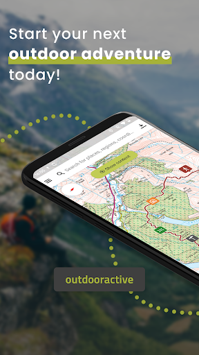
The Outdooractive App for smartphones, tablets & Wear OS is the perfect companion for hiking, cycling, mountaineering and other outdoor activities. With the app you can find and plan routes around the world with ease.
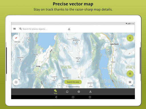
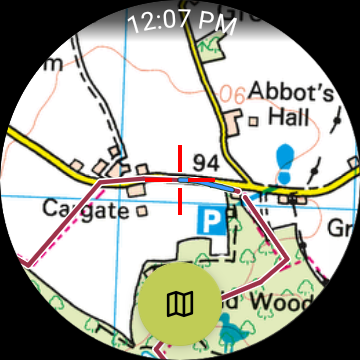
Latest vector maps provide accurate information about hiking and cycling trails, via ferratas, protected areas and details about many other outdoor activities.
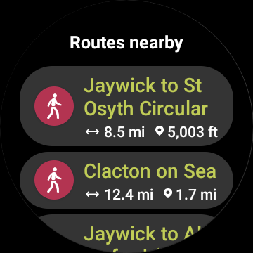
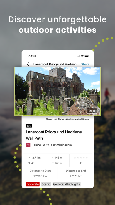
Global Trail Database:
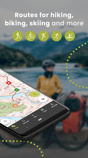
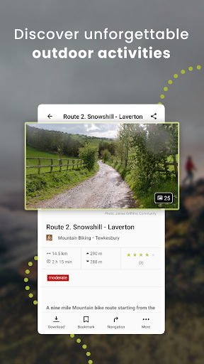
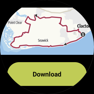
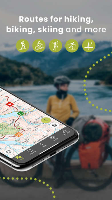
Browse through countless route suggestions for hiking, cycling and ski touring. All routes come with full details, elevation profiles, photos and directions.
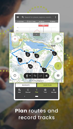
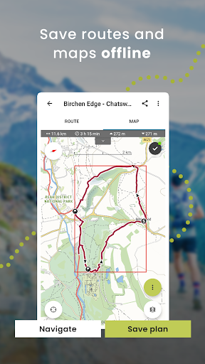
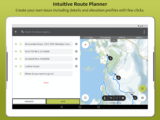
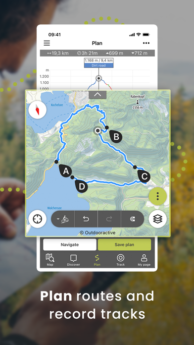
Outdoor Route Planner:
Our Route Planner lets you easily plan and create routes based on your preferences. You can add text and photos to these, publish them within the Community or share them privately with friends. You can also import and export GPX files as required.
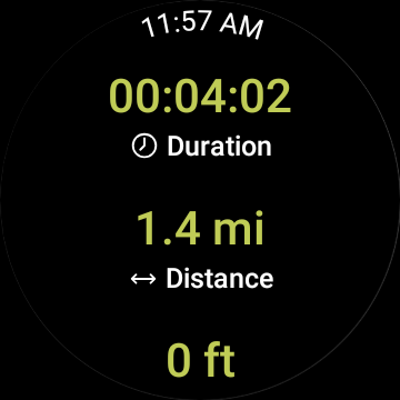
Recording your own Tracks:
The tracking function allows you to record your own tracks to include duration, distance, altitudes and an interactive altitude profile.
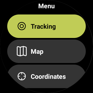
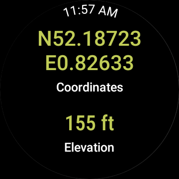
Smartwatches with WEAR OS from Google:
Save maps to your watch and use them offline, letting you leave your phone at home. Record tracks and upload them directly to your account. Works without a data connection
Challenges:
Join one of our walk, cycle, climb or run challenges. Pick your activity and choose the distance to complete this year.
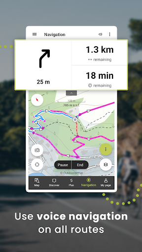
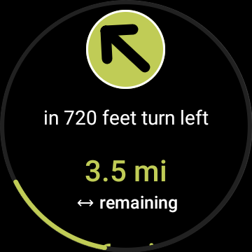
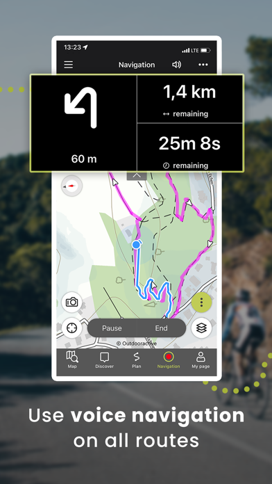
Navigation:
The navigation function with speech output lets you navigate comfortably from A to B on all routes.
BuddyBeacon:
Safety first: Share your real-time location with friends and family.
State-of-the-art map technology:
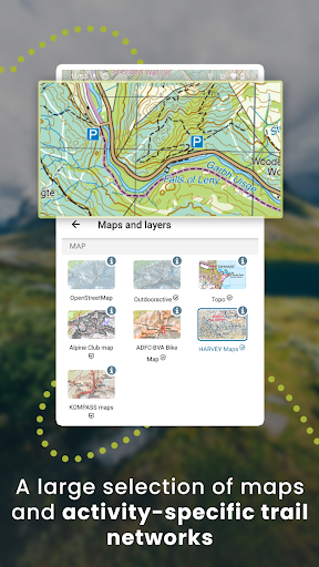
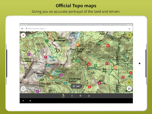
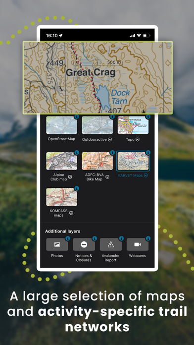
Enjoy a high-resolution display of all maps and at all zoom levels thanks to our state-of-the-art vector technology. Our digital summer and winter layers are based on OpenStreetMap and Pro and Pro+ members can also benefit from many other maps.
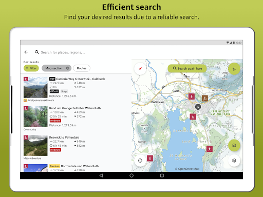
A Global Outdoor Travel Guide:
Helpful filters and our powerful search functions help you not only find routes, but also sights, accommodation, events and ski resorts.
A Large Directory of Mountain Huts:
Opening times, availability and prices as well as further information can all be found in our mountain hut directory. Created in partnership with the German Alpine Association (DAV), the Austrian Alpine Association (ÖAV) and the Alpine Association for South Tyrol (AVS).
Exclusively for Pro members
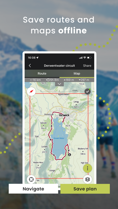
Go anywhere : Outdooractive Pro works offline without mobile and data signals. Unlimited lists can also be created and the app is ad-free. In addition, you are able to view satellite imagery, the unique Outdooractive map with over 30 activity trail networks and official topographic maps from the following providers:
Great Britain Ordnance Survey, Landranger, Explorer
New Zealand Land Information
Utah USGS
Germany BKG
Austria BEV
Switzerland swisstopo
France IGN
Spain CNIG
Italy Edizione il Lupo, 4Land and others
Netherlands PDOK
Norway Kartverket
Denmark Kortforsyningen
Sweden Lantmäteriet
Finland National Land Survey
Japan GSI
Global Map
Exclusively for Pro+ members
Pro+ also contains official maps from Alpine Associations as well as premium maps from KOMPASS and certified Premium Routes from KOMPASS, Schall Verlag and the ADAC hiking guides.
If you have questions or suggestions, please visit https://www.outdooractive.com/en/helpcenter/
Latest vector maps provide accurate information about hiking and cycling trails, via ferratas, protected areas and details about many other outdoor activities.
Global Trail Database:
Browse through countless route suggestions for hiking, cycling and ski touring. All routes come with full details, elevation profiles, photos and directions.
Outdoor Route Planner:
Our Route Planner lets you easily plan and create routes based on your preferences. You can add text and photos to these, publish them within the Community or share them privately with friends. You can also import and export GPX files as required.
Recording your own Tracks:
The tracking function allows you to record your own tracks to include duration, distance, altitudes and an interactive altitude profile.
Smartwatches with WEAR OS from Google:
Save maps to your watch and use them offline, letting you leave your phone at home. Record tracks and upload them directly to your account. Works without a data connection
Challenges:
Join one of our walk, cycle, climb or run challenges. Pick your activity and choose the distance to complete this year.
Navigation:
The navigation function with speech output lets you navigate comfortably from A to B on all routes.
BuddyBeacon:
Safety first: Share your real-time location with friends and family.
State-of-the-art map technology:
Enjoy a high-resolution display of all maps and at all zoom levels thanks to our state-of-the-art vector technology. Our digital summer and winter layers are based on OpenStreetMap and Pro and Pro+ members can also benefit from many other maps.
A Global Outdoor Travel Guide:
Helpful filters and our powerful search functions help you not only find routes, but also sights, accommodation, events and ski resorts.
A Large Directory of Mountain Huts:
Opening times, availability and prices as well as further information can all be found in our mountain hut directory. Created in partnership with the German Alpine Association (DAV), the Austrian Alpine Association (ÖAV) and the Alpine Association for South Tyrol (AVS).
Exclusively for Pro members
Go anywhere : Outdooractive Pro works offline without mobile and data signals. Unlimited lists can also be created and the app is ad-free. In addition, you are able to view satellite imagery, the unique Outdooractive map with over 30 activity trail networks and official topographic maps from the following providers:
Great Britain Ordnance Survey, Landranger, Explorer
New Zealand Land Information
Utah USGS
Germany BKG
Austria BEV
Switzerland swisstopo
France IGN
Spain CNIG
Italy Edizione il Lupo, 4Land and others
Netherlands PDOK
Norway Kartverket
Denmark Kortforsyningen
Sweden Lantmäteriet
Finland National Land Survey
Japan GSI
Global Map
Exclusively for Pro+ members
Pro+ also contains official maps from Alpine Associations as well as premium maps from KOMPASS and certified Premium Routes from KOMPASS, Schall Verlag and the ADAC hiking guides.
If you have questions or suggestions, please visit https://www.outdooractive.com/en/helpcenter/
{{descriptionMoreText}}
Comments (1)
{{commentText.length}}/{{maxCommentText}}
{{commentError}}{{commentUserError}}
-
{{comment.commentUser.substring(0, 1)}}By {{comment.commentUser}}{{comment.commentDateString}}
-
LBy Lubis AnsariAug 10,2022


Category Top
apps
- Google Play
- App Store
4
5
Lifestyle
 Daily Diary:Journal with Lock
 Life360: Find Family & Friends
 Pinterest
 T-Mobile Tuesdays
 Frecuencia
Photography
 Picsart AI Photo Editor, Video
 Amazon Photos
 Time Warp Scan - Face Scanner
 ToonApp: Cartoon Photo Editor
 Pixelup - AI Photo Enhancer


More Apps


