


 Art & Design
 Auto & Vehicles
 Beauty
 Business
 Education
 Entertainment
 Finance
 Food & Drink
 Health & Fitness
 House & Home
 Libraries & Demo
 Maps & Navigation
 Medical
 Music & Audio
 Parenting
 Personalization
 Photography
 Productivity
 Shopping
 Social
 Sports
 Tools
Tools Travel & Local
 Video Players
 Weather
 Family


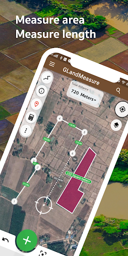
 Measure area GPS GLandMeasure
OS :
Version :3.2.2
Size :
Updated :Sep 1,2022
Developer :ToptoshirouApp
 Ask AI
You can ask
the AI some questions about the app
Here are three potential discussion topics related to the app, turned into questions:
1. What features of the terrain measurement app have you found most useful for your outdoor activities?
2. How accurate do you think the app's measurements are, and have you noticed any errors or discrepancies?
3. What kind of obstacles or challenges have you encountered while using the app, and how did you overcome them?
 Ask AI
App
Downloads
<
>


App
Survey
-
Do you think the payment of application features affects the experience?
-
Do you group them together?
-
How much time do you spend on app applications every day?
-
Do you often use the tools app that comes with your phone
Description
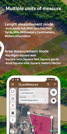
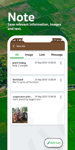
GLandMeasure is a free app for measuring areas and lengths that can be used to measure land, farm, field, home, distance, and length measurement easily. With the method of pinning on the map Or use the actual walking method Which the app will calculate the area And length automatically You can also choose from several types of measurement units. And can also be able to easily share images of the area Just a few steps
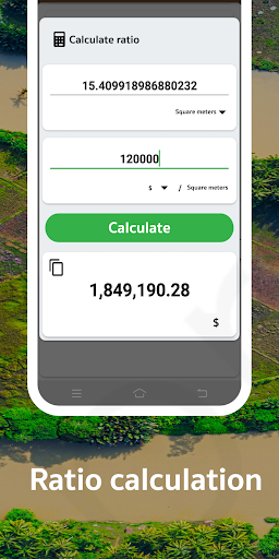
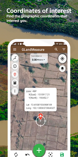
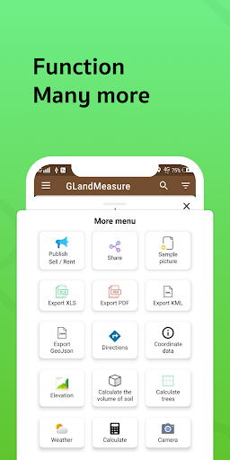
It covers the use of people who work in real estate as well. Including farmers who want to use it, it is considered an answer. After measuring the area, you can export your coordinates in a variety of formats, such as land sales announcements. Real Estate Society, PDF, Excel, KML, Geojson, map photos, route finder, elevation, soil cue calculations, tree counts in area, weather forecasts, calculations and cameras.
Support various tools compass tool convert measurement units Coordinate unit converter GEO(Lat Long) UTM MGRS Geojson geographic camera
Supports multiple layers: WMS, XYZ Tiles, Image Layers, Current Rain Layers.
Support to create multiple projects
Support for displaying large amounts of data
{{descriptionMoreText}}
Comments (4)
{{commentText.length}}/{{maxCommentText}}
{{commentError}}{{commentUserError}}
-
{{comment.commentUser.substring(0, 1)}}By {{comment.commentUser}}{{comment.commentDateString}}
-
IBy Iftakher UddinAug 15,2022
-
XBy Xtylish KhanAug 15,2022
-
BBy Bharat KumarAug 13,2022
-
cBy christopher chendalumbiAug 11,2022
Category Top
apps
- Google Play
- App Store
4
5
Lifestyle
 Daily Diary:Journal with Lock
 Life360: Find Family & Friends
 Pinterest
 T-Mobile Tuesdays
 Frecuencia
Photography
 Picsart AI Photo Editor, Video
 Amazon Photos
 Time Warp Scan - Face Scanner
 ToonApp: Cartoon Photo Editor
 Pixelup - AI Photo Enhancer


More Apps


