


 Art & Design
 Auto & Vehicles
 Beauty
 Business
 Education
 Entertainment
 Finance
 Food & Drink
 Health & Fitness
 House & Home
 Libraries & Demo
 Maps & Navigation
 Medical
 Music & Audio
 Parenting
 Personalization
 Photography
 Productivity
 Shopping
 Social
 Sports
 Tools
Tools Travel & Local
 Video Players
 Weather
 Family


 i-Boating:UK/Ireland:Marine
OS :
Version :86.0
Size :
Updated :Jun 20,2016
Developer :Gps Nautical Charts
 Ask AI
You can ask
the AI some questions about the app
Here are three topics that users might discuss about this app on the Internet:
1. What features do you expect to find in the Nautical Almanac on this app?
2. How does the celestial navigation function work on this app?
3. Can you synchronize your navigation data across multiple devices with this app?
 Ask AI
App
Downloads
<
>


App
Survey
-
The degree of memory and power consumption Does it affect the experience?
-
How much time do you spend on app applications every day?
-
Do you think the stability of the application affects the experience?
-
Application technology innovation Does it affect the experience?
Description
This App offers access to marine vector covering UK/Ireland waters (derived from UKHO data). First marine GPS app to have route assistance with Voice Prompts for marine navigation. You can create new boating routes or import existing GPX/KML routes. It supports Nautical Charts course up orientation. Includes Tide & Currents prediction.
►FEATURES
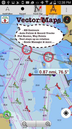
√ Beautiful and detailed Hardware/GPU accelerated vector charts (text stays upright on rotation)
√ Long press to query the details of Marine object (Buoy, Lights, Obstruction etc).
√ Customizable depth(Ft/Fathom/Meter) and distance units (km/mi/NM)
√ Customizable Shallow Depth.
√ Record tracks, Autofollow with real-time track overlay & predicted path vector.
√ Voice Prompts for marine navigation (requires GPS )
√ 1ft / 3ft depth contour maps for anglers for selected lake maps.
√ Supports GPX/KML for boating route editing/import.
√ Tide & Currents prediction.
√ Seamless chart quilting of marine charts
√ Enter or import Waypoints.
► MAPS
The maps include coverage of coast of UK & Ireland (derived from UKHO data).
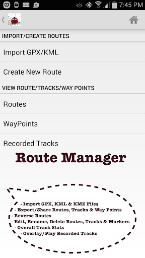
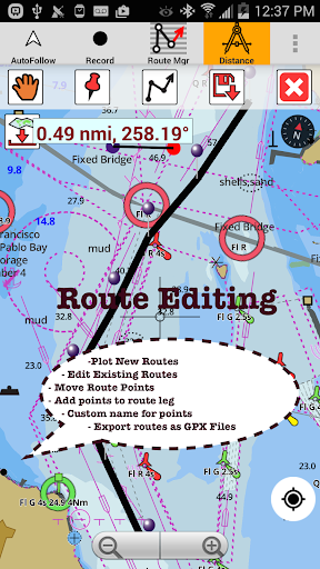
►ROUTE MANAGEMENT / TRIP PLANNING
√ Create New Route/Edit Existing Routes
√ Move Points
√ Add points to an existing route leg
√ Delete / Rename points
√ Import GPX, KML & KMZ files
√ Plot/Edit Routes
√ Enter Waypoints
√ Share/Export Routes, Tracks & Markers
√ Reverse Routes
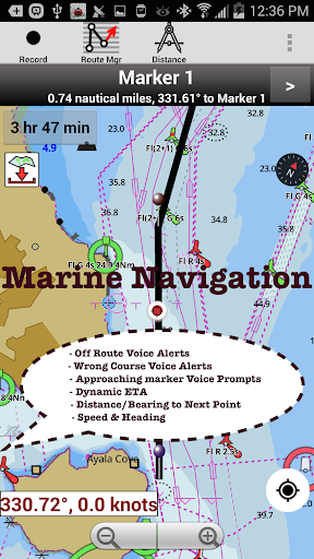
►GPS FEATURES
√ Auto Follow
* Real Time Track Overlay
* Predicted Path Vector
* Course Up (Text stays upright)
* Speed & Heading
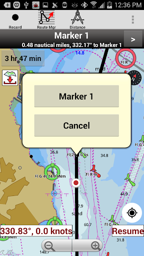
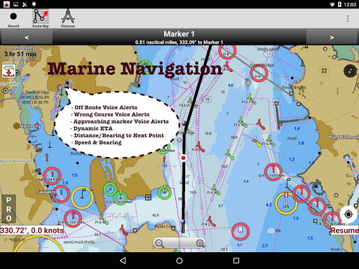
√ Route Assistance With Voice Prompts
* Prompts when approaching a boating route marker
* Continous distance and ETA updates
* Alerts when sailing/boating off route
* Alerts when boating in wrong direction
√ Record Tracks
►NMEA Instrumentats
√ AIS & GPS(NMEA over TCP/UDP)
√ Wind direction & Speed,Sonar depth,Water temperature
► Available Chart folios
√ BRISTOL CHANNEL & SOUTH IRELAND
√ ENGLAND S COAST & SCILLIES
√ IRELAND W C-KENMARE R-FORELAND
√ IRISH SEA
√ N&E SCOTLAND-LEWIS-FORTH-N ISLES
√ NORTH SEA-FORTH-THAMES ENTRANCE
√ SCOTLAND KINTYRE-LOCH BROOM
√ THAMES-MEDWAY & APPROACHES
►TIDE & CURRENTS
* For US, Canada, UK, Germany & New Zealand
* High/Low Tides
* Tidal Current Prediction
* Active Current Stations
► SHARING
* Share tracks/routes/markers on Facebook & Twitter
* Export tracks/routes/markers as compressed GPX files.
►Custom Base Map
√ Satellite/Aerial Imagery, Street Maps etc.
►Online Chart Viewer
http://fishing-app.gpsnauticalcharts.com/i-boating-fishing-web-app/fishing-marine-charts-navigation.html#12.21/51.4638/0.4629
►FEATURES
√ Beautiful and detailed Hardware/GPU accelerated vector charts (text stays upright on rotation)
√ Long press to query the details of Marine object (Buoy, Lights, Obstruction etc).
√ Customizable depth(Ft/Fathom/Meter) and distance units (km/mi/NM)
√ Customizable Shallow Depth.
√ Record tracks, Autofollow with real-time track overlay & predicted path vector.
√ Voice Prompts for marine navigation (requires GPS )
√ 1ft / 3ft depth contour maps for anglers for selected lake maps.
√ Supports GPX/KML for boating route editing/import.
√ Tide & Currents prediction.
√ Seamless chart quilting of marine charts
√ Enter or import Waypoints.
► MAPS
The maps include coverage of coast of UK & Ireland (derived from UKHO data).
►ROUTE MANAGEMENT / TRIP PLANNING
√ Create New Route/Edit Existing Routes
√ Move Points
√ Add points to an existing route leg
√ Delete / Rename points
√ Import GPX, KML & KMZ files
√ Plot/Edit Routes
√ Enter Waypoints
√ Share/Export Routes, Tracks & Markers
√ Reverse Routes
►GPS FEATURES
√ Auto Follow
* Real Time Track Overlay
* Predicted Path Vector
* Course Up (Text stays upright)
* Speed & Heading
√ Route Assistance With Voice Prompts
* Prompts when approaching a boating route marker
* Continous distance and ETA updates
* Alerts when sailing/boating off route
* Alerts when boating in wrong direction
√ Record Tracks
►NMEA Instrumentats
√ AIS & GPS(NMEA over TCP/UDP)
√ Wind direction & Speed,Sonar depth,Water temperature
► Available Chart folios
√ BRISTOL CHANNEL & SOUTH IRELAND
√ ENGLAND S COAST & SCILLIES
√ IRELAND W C-KENMARE R-FORELAND
√ IRISH SEA
√ N&E SCOTLAND-LEWIS-FORTH-N ISLES
√ NORTH SEA-FORTH-THAMES ENTRANCE
√ SCOTLAND KINTYRE-LOCH BROOM
√ THAMES-MEDWAY & APPROACHES
►TIDE & CURRENTS
* For US, Canada, UK, Germany & New Zealand
* High/Low Tides
* Tidal Current Prediction
* Active Current Stations
► SHARING
* Share tracks/routes/markers on Facebook & Twitter
* Export tracks/routes/markers as compressed GPX files.
►Custom Base Map
√ Satellite/Aerial Imagery, Street Maps etc.
►Online Chart Viewer
http://fishing-app.gpsnauticalcharts.com/i-boating-fishing-web-app/fishing-marine-charts-navigation.html#12.21/51.4638/0.4629
{{descriptionMoreText}}
Comments (5)
{{commentText.length}}/{{maxCommentText}}
{{commentError}}{{commentUserError}}
-
{{comment.commentUser.substring(0, 1)}}By {{comment.commentUser}}{{comment.commentDateString}}
-
SBy Shane FlahertyAug 9,2022
-
IBy Ian StothersMar 14,2022
-
ABy A Google userDec 13,2019
-
ABy A Google userOct 15,2018
-
ABy A Google userJul 25,2018

Category Top
apps
- Google Play
- App Store
4
5
Lifestyle
 Daily Diary:Journal with Lock
 Life360: Find Family & Friends
 Pinterest
 T-Mobile Tuesdays
 Frecuencia
Photography
 Picsart AI Photo Editor, Video
 Amazon Photos
 Time Warp Scan - Face Scanner
 ToonApp: Cartoon Photo Editor
 Pixelup - AI Photo Enhancer


More Apps


