


 Art & Design
 Auto & Vehicles
 Beauty
 Business
 Education
 Entertainment
 Finance
 Food & Drink
 Health & Fitness
 House & Home
 Libraries & Demo
 Maps & Navigation
 Medical
 Music & Audio
 Parenting
 Personalization
 Photography
 Productivity
 Shopping
 Social
 Sports
 Tools
Tools Travel & Local
 Video Players
 Weather
 Family


 GPX track viewer
OS :
Version :1.2.0
Size :
Updated :Sep 8,2021
Developer :Yevgeniy Tyumen
 Ask AI
 Ask AI
Pros and Cons from users' feedback
Based on the users' reviews of the GPX Track Viewer app, here are three pros and cons in 15 words or less:
**Pros:**
1. User-friendly interface makes it easy to view and analyze track data.
2. Supports various file formats, including GPX, KML, and TCX.
3. Provides detailed information about track distances, elevations, and statistics.
**Cons:**
1. Limited customization options for map display and layout.
2. Some users experience issues with slow loading times and crashes.
3. Lacking advanced features, such as route planning and sharing options.
App
Downloads
<
>


App
Survey
-
How much time do you spend on app applications every day?
-
Whether the application ad recommendation affects the experience?
-
Ease of use of the application Does it affect the experience?
-
Do you think the payment of application features affects the experience?
Description
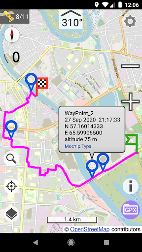
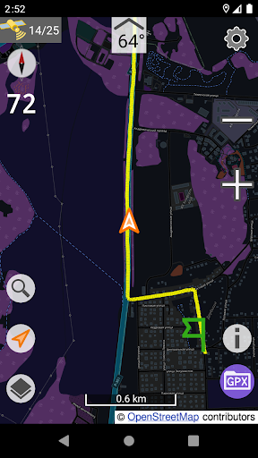
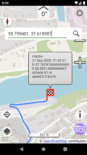
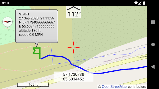
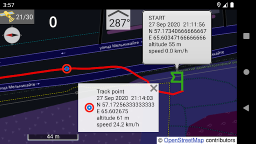
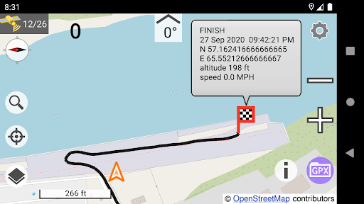
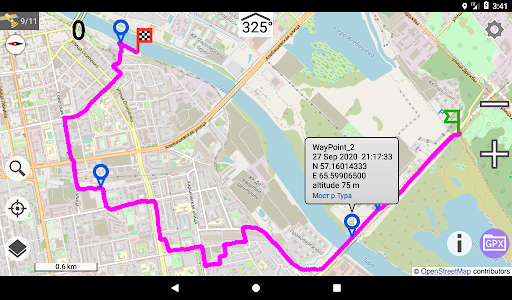
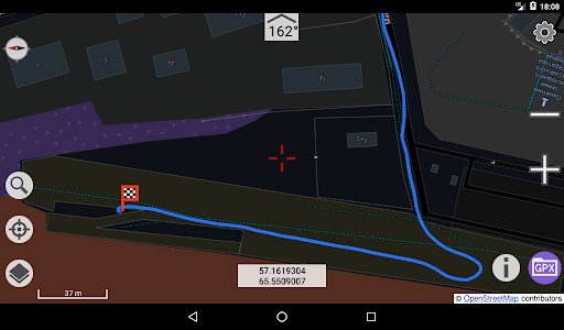
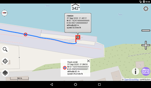
GPX track viewer is a simple application for viewing GPX tracks created by the GNSS Speedometer app.
Based on osmdroid — https://github.com/osmdroid/osmdroid
FEATURES
- Select the appearance of the track
- Track information: waypoints, distance, time, speed, start, finish, etc.
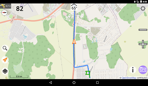
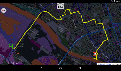
- Digital compass (if available on your device)
- GPS/GNSS status
- Direction from map center to the top: 0° — North on the top, 90° — East, 180° — South, 270° — West. When the "Follow my location" mode with map auto-rotation is enabled, the direction will also be the course of movement.
- Marker and coordinates of the map center
- Current speed
- Units of measurement: km or miles
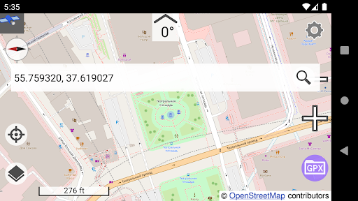
- Search by coordinates in the format that the "GNSS speedometer" app can send
IMPLICIT FEATURES
Long click on the direction to enable / disable the rotation of the map, click to reset to 0°.
Long click on "My location” — enable / disable "Follow my location".
Long click on coordinates to send coordinates to someone in a format identical to that sent from "GNSS speedometer" app.
Long click on "Search" to enlarge tiles scale (to enlarge the text on the map).
In the app settings, long click on the "Day" button to save the current display brightness as the brightness for the "Day" theme, long click on the "Night" button to save the current display brightness as the brightness for the “Night” theme.
In ”TRACK INFO", click on "Start point” to go to the map to the start point, click on "End point” to go to the map to the end point.
PERMISSIONS
Location permission is needed to display your location on the map.
Write system settings permission is needed to control the brightness of the display.
Internet access is required to download maps.
Privacy policy — https://sites.google.com/view/gpxtrackviewer/policy
More information —
https://sites.google.com/view/gpxtrackviewer/description
Based on osmdroid — https://github.com/osmdroid/osmdroid
FEATURES
- Select the appearance of the track
- Track information: waypoints, distance, time, speed, start, finish, etc.
- Digital compass (if available on your device)
- GPS/GNSS status
- Direction from map center to the top: 0° — North on the top, 90° — East, 180° — South, 270° — West. When the "Follow my location" mode with map auto-rotation is enabled, the direction will also be the course of movement.
- Marker and coordinates of the map center
- Current speed
- Units of measurement: km or miles
- Search by coordinates in the format that the "GNSS speedometer" app can send
IMPLICIT FEATURES
Long click on the direction to enable / disable the rotation of the map, click to reset to 0°.
Long click on "My location” — enable / disable "Follow my location".
Long click on coordinates to send coordinates to someone in a format identical to that sent from "GNSS speedometer" app.
Long click on "Search" to enlarge tiles scale (to enlarge the text on the map).
In the app settings, long click on the "Day" button to save the current display brightness as the brightness for the "Day" theme, long click on the "Night" button to save the current display brightness as the brightness for the “Night” theme.
In ”TRACK INFO", click on "Start point” to go to the map to the start point, click on "End point” to go to the map to the end point.
PERMISSIONS
Location permission is needed to display your location on the map.
Write system settings permission is needed to control the brightness of the display.
Internet access is required to download maps.
Privacy policy — https://sites.google.com/view/gpxtrackviewer/policy
More information —
https://sites.google.com/view/gpxtrackviewer/description
{{descriptionMoreText}}
Comments (0)
{{commentText.length}}/{{maxCommentText}}
{{commentError}}{{commentUserError}}
-
{{comment.commentUser.substring(0, 1)}}By {{comment.commentUser}}{{comment.commentDateString}}
Developer apps
Category Top
apps
- Google Play
- App Store
4
5
Lifestyle
 Daily Diary:Journal with Lock
 Life360: Find Family & Friends
 Pinterest
 T-Mobile Tuesdays
 Frecuencia
Photography
 Picsart AI Photo Editor, Video
 Amazon Photos
 Time Warp Scan - Face Scanner
 ToonApp: Cartoon Photo Editor
 Pixelup - AI Photo Enhancer


More Apps


