


 Art & Design
 Auto & Vehicles
 Beauty
 Business
 Education
 Entertainment
 Finance
 Food & Drink
 Health & Fitness
 House & Home
 Libraries & Demo
 Lifestyle
 Maps & Navigation
 Medical
 Music & Audio
 Parenting
 Personalization
 Photography
 Productivity
 Shopping
 Social
 Sports
 Tools
Tools Travel & Local
 Video Players
 Weather
 Family


 Amsterdam Rail Map Lite
OS :
Version :5.5
Size :15.61Mb
Updated :Aug 11,2017
Developer :Urban-Map
 Ask AI
You can ask
the AI some questions about the app
Here are three topics that users may discuss about the Amsterdam Rail Map Lite app, turned into questions for you:
1. How does the app's route planning feature help you navigate Amsterdam's public transportation system?
2. Are the maps and schedules in the app accurate and up-to-date, and do they cover all necessary routes?
3. Is the app user-friendly and easy to use, even for those who are not familiar with Amsterdam's rail network?
 Ask AI
Pros and Cons from users' feedback
I'd be happy to help you with that! After analyzing the user reviews on the Apple App Store, here are three pros and three cons of the Amsterdam Rail Map Lite app:
Pros:
1. Accurate and detailed maps make it easy to navigate Amsterdam's rail network.
2. User-friendly interface allows for quick and simple route planning.
3. Offline access ensures seamless travel even without internet connectivity.
Cons:
1. Limited features compared to the full version, which may be frustrating for some users.
2. Some users experienced issues with map loading and navigation.
3. Lack of real-time updates for train schedules and delays can be inconvenient.
Please let me know if you'd like me to elaborate on any of these points or if you have any further questions!
App
Downloads
<
>


App
Survey
-
Do you think the payment of application features affects the experience?
-
Ease of use of the application Does it affect the experience?
-
Do you think the aesthetics of the interface UI affects the experience?
-
Whether the application ad recommendation affects the experience?
Description
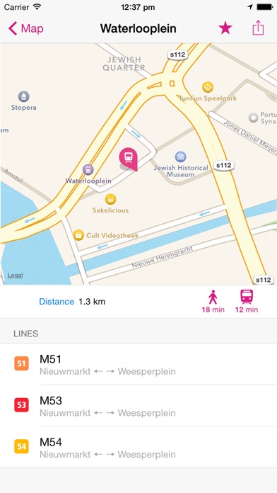
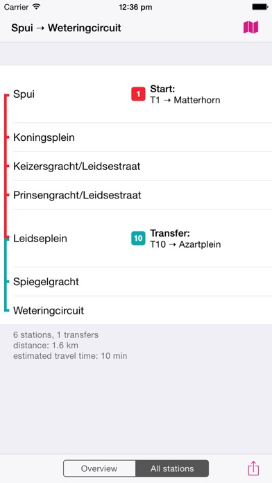
Rail & Subway Map is a clear and concise route map that features:
THE MOST BEAUTIFUL RAIL MAP - representing the state of the art in information design.
ROUTE PLANNER - instantly finds the fastest route and displays it on the map including transfer stations.
STATIONS INDEX - quickly jump to any station.
LINES OVERVIEW - shows the order of stations on each line with transit options.
DAY and NIGHT MAPS - for easy legibility switching between a light and dark version of the map is possible. This can also be done automatically depending on the time of day.
GPS SUPPORT - find the station closest to you.
HIGH RESOLUTION GRAPHICS - looks stunning on retina displays.
ROTATE and ZOOM - hold your device any way you want.
UNIVERSAL APP - optimized for iPhone, iPod Touch and iPad.
LARGE MAP - includes the most important stations
STATION LOOKUP - search for a station by name
APPLE MAPS INTEGRATION - lookup your route directly from Apple Maps
The LITE-Version is fully functional but needs an internet connection. If you like the app but need offline access you can get the regular version for a big discount. (Only for limited time!)
=========
Disclaimer:
Continued use of GPS running in the background can dramatically decrease battery life.
{{descriptionMoreText}}
Comments (0)
{{commentText.length}}/{{maxCommentText}}
{{commentError}}{{commentUserError}}
-
{{comment.commentUser.substring(0, 1)}}By {{comment.commentUser}}{{comment.commentDateString}}
Developer apps


Category Top
apps
- Google Play
- App Store


More Apps


