


 Art & Design
 Auto & Vehicles
 Beauty
 Business
 Education
 Entertainment
 Finance
 Food & Drink
 Health & Fitness
 House & Home
 Libraries & Demo
 Maps & Navigation
 Medical
 Music & Audio
 Parenting
 Personalization
 Photography
 Productivity
 Shopping
 Social
 Sports
 Tools
Tools Travel & Local
 Video Players
 Weather
 Family


 Altimeter
OS :
Version :4.7.07
Size :
Updated :Jun 21,2022
Developer :EXA Tools
 Ask AI
You can ask
the AI some questions about the app
Here are three topics that users may discuss about the Altimeter app, transformed into questions with 20 words each:
1. How accurate is the Altimeter app's altitude measurement, and does it provide reliable readings in various environments?
2. Can I use the Altimeter app to track my outdoor activities, such as hiking or mountaineering, and what features support this use case?
3. Are there any limitations or restrictions on using the Altimeter app, such as requiring a physical GPS device or specific permissions?
 Ask AI
App
Downloads
<
>


App
Survey
-
Application interactivity Does it affect the experience?
-
Whether the application ad recommendation affects the experience?
-
Have you ever thought of deleting them?
-
What is your Mobile System?
Description
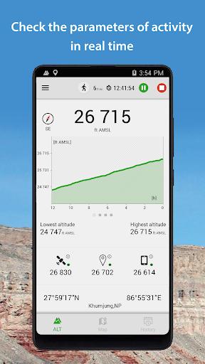
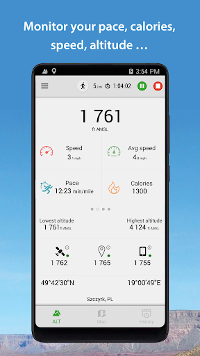
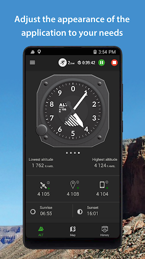
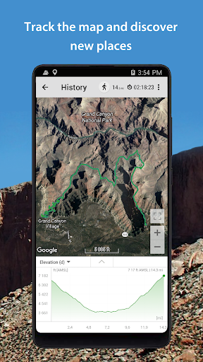
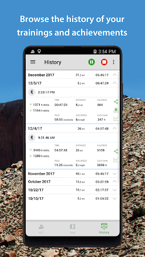
Altimeter is a smart tracking devices, used to altitude measure. It is perfect app for people who love hiking, skiing, mountain biking and other outdoor activities. Any time and with high precision you can check altitude, elevation or localization coordinates. It works online and offline.
This altimeter app, to measure altitude uses:
- GPS satellites triangulation - works without internet connection,
- barometer pressure sensor (if available in your device) - high accurate data; if internet connection is available it calibrates itself to improve accuracy,
- online networks location services (wifi and other) - need internet connection.
You can use each sensor separate or all together.
App altitude meter includes the following features:
- accurate measurement of altitude - indication in meters or feet
- record of: lowest (low), highest (max) altitude
- smart mini compass
- full GPS coordinates - latitude and longitude
- current localization name and state
- results of measurements are shown in the chart
- ability to stop and record the results of measurements at any time
- invert background color (black and white)
- share summit top altitude pics - share photo with altitude to your friends or export them to save place.
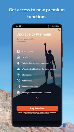
All features are free. You can remove all ads from app by purchase "no ads".
Enjoy with this altimeter app !
This altimeter app, to measure altitude uses:
- GPS satellites triangulation - works without internet connection,
- barometer pressure sensor (if available in your device) - high accurate data; if internet connection is available it calibrates itself to improve accuracy,
- online networks location services (wifi and other) - need internet connection.
You can use each sensor separate or all together.
App altitude meter includes the following features:
- accurate measurement of altitude - indication in meters or feet
- record of: lowest (low), highest (max) altitude
- smart mini compass
- full GPS coordinates - latitude and longitude
- current localization name and state
- results of measurements are shown in the chart
- ability to stop and record the results of measurements at any time
- invert background color (black and white)
- share summit top altitude pics - share photo with altitude to your friends or export them to save place.
All features are free. You can remove all ads from app by purchase "no ads".
Enjoy with this altimeter app !
{{descriptionMoreText}}
Comments (5)
{{commentText.length}}/{{maxCommentText}}
{{commentError}}{{commentUserError}}
-
{{comment.commentUser.substring(0, 1)}}By {{comment.commentUser}}{{comment.commentDateString}}
-
TBy Tanti SariAug 19,2022
-
TBy Takabeya 19Aug 13,2022
-
IBy Ican HutabaratAug 13,2022
-
SBy SAIFUL BAHRIAug 7,2022
-
ABy Athala NafeezaAug 1,2022
Developer apps


Category Top
apps
- Google Play
- App Store
4
5
Lifestyle
 Daily Diary:Journal with Lock
 Life360: Find Family & Friends
 Pinterest
 T-Mobile Tuesdays
 Frecuencia
Photography
 Picsart AI Photo Editor, Video
 Amazon Photos
 Time Warp Scan - Face Scanner
 ToonApp: Cartoon Photo Editor
 Pixelup - AI Photo Enhancer


More Apps


