


 Art & Design
 Auto & Vehicles
 Beauty
 Business
 Education
 Entertainment
 Finance
 Food & Drink
 Health & Fitness
 House & Home
 Libraries & Demo
 Maps & Navigation
 Medical
 Music & Audio
 Parenting
 Personalization
 Photography
 Productivity
 Shopping
 Social
 Sports
 Tools
Tools Travel & Local
 Video Players
 Weather
 Family


 Altimeter Mountain GPS Tracker
OS :

Version :3.3/3.2.8
Size :/55.13Mb
Updated :Sep 7,2022
Jul 20,2022
Jul 20,2022
Developer :Mystic Mobile Apps GPS Tools
 Ask AI
 Ask AI
Pros and Cons from users' feedback
Based on the user reviews, here are three pros and three cons of the Altimeter app:
**Pros:**
1. "Accurate readings and easy to use, perfect for hiking and outdoor activities."
2. "User-friendly interface and frequent updates, a great value for the price."
3. "Helpful for tracking altitude and distance, perfect for fitness enthusiasts."
**Cons:**
1. "Noisy and sometimes inaccurate measurements, can be frustrating for users."
2. " Ads are quite intrusive and disrupt the user experience, inconvenient."
3. "In-app purchases can be confusing and not well-explained, frustrating buyers."
<
>


App
Survey
-
Do you think the stability of the application affects the experience?
-
Whether the app response speed affects the experience?
-
Why do you uninstall an app?
-
What is the number of APPs on your phone?
Description
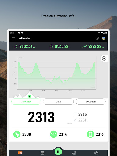
Turn your smartphone into a multi-functioned altimeter. Our unique algorithms determine your elevation using three sources - the GPS system in your phone, network services, and when available, your device’s barometer. Our algorithm combines data from all three sources to give you the most accurate reading possible.
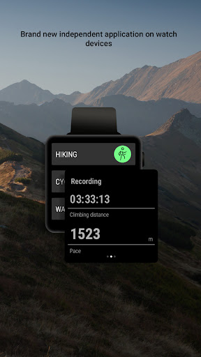
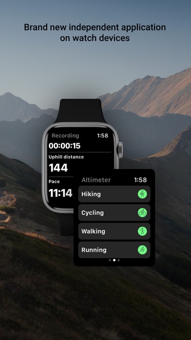
Our app comes with a brand new independent application for watch devices. You can easily track your hiking without using your phone and synchronize data afterwards to enjoy viewing your routes on a bigger screen!
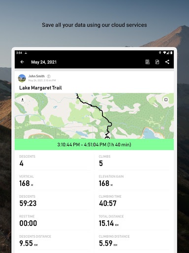
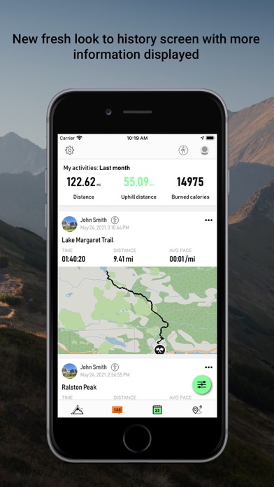
Know your exact heading on your current route, view your current position on the map and use the app to track any route you choose. The app tracks, follows and displays your route in real time, displays it and then draws elevation and speed charts during your trip. Kick back in your favorite chair after a long trip and view all of the adventures you’ve been on, our app automatically saves all of them in our database.
Tap or move your finger on or over any value on the chart to know when and where a particular value occurred. You can also choose from multiple functions such as speedometer, calorie counter, checkpoint times, notification sounds at preset milestones, and even auto pause should you decide to stop somewhere for coffee or to take a photo. If you do stop to take photos, they can easily be added with the data of your current position overplayed right on top! Your photos will have elevation, average speed, location info right on them!
Our app will also save all data associated with your account so that, should you choose to switch smartphones, nothing will be lost. Simply log in with the new device and pick up where you left off.
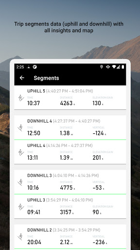
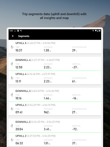
One of the coolest features of the app is that it divides your route into segments. In the segments screen you can see separate uphill/downhill data, you can easily check how long it took you to climb a mountain, your recent pace and elevation gain or how fast you went downhill later on. You can go into the details of the segment on the map, see a full chart and all data displayed on a list.
If you want to see your route in Maps or another application you can easily export track data to following formats:
- GPX
- KML
- KMZ
Terms and conditions: https://mysticmobileapps.com/legal/terms/altimeter.html
Privacy policy: https://mysticmobileapps.com/legal/privacy/altimeter.html
Our app comes with a brand new independent application for watch devices. You can easily track your hiking without using your phone and synchronize data afterwards to enjoy viewing your routes on a bigger screen!
Know your exact heading on your current route, view your current position on the map and use the app to track any route you choose. The app tracks, follows and displays your route in real time, displays it and then draws elevation and speed charts during your trip. Kick back in your favorite chair after a long trip and view all of the adventures you’ve been on, our app automatically saves all of them in our database.
Tap or move your finger on or over any value on the chart to know when and where a particular value occurred. You can also choose from multiple functions such as speedometer, calorie counter, checkpoint times, notification sounds at preset milestones, and even auto pause should you decide to stop somewhere for coffee or to take a photo. If you do stop to take photos, they can easily be added with the data of your current position overplayed right on top! Your photos will have elevation, average speed, location info right on them!
Our app will also save all data associated with your account so that, should you choose to switch smartphones, nothing will be lost. Simply log in with the new device and pick up where you left off.
One of the coolest features of the app is that it divides your route into segments. In the segments screen you can see separate uphill/downhill data, you can easily check how long it took you to climb a mountain, your recent pace and elevation gain or how fast you went downhill later on. You can go into the details of the segment on the map, see a full chart and all data displayed on a list.
If you want to see your route in Maps or another application you can easily export track data to following formats:
- GPX
- KML
- KMZ
Terms and conditions: https://mysticmobileapps.com/legal/terms/altimeter.html
Privacy policy: https://mysticmobileapps.com/legal/privacy/altimeter.html
{{descriptionMoreText}}
Comments (1)
{{commentText.length}}/{{maxCommentText}}
{{commentError}}{{commentUserError}}
-
{{comment.commentUser.substring(0, 1)}}By {{comment.commentUser}}{{comment.commentDateString}}
-
aBy andreas ullrichAug 8,2022
Developer apps
- Google Play
- App Store


Category Top
apps
- Google Play
- App Store
4
5
Lifestyle
 Daily Diary:Journal with Lock
 Life360: Find Family & Friends
 Pinterest
 T-Mobile Tuesdays
 Frecuencia
Photography
 Picsart AI Photo Editor, Video
 Amazon Photos
 Time Warp Scan - Face Scanner
 ToonApp: Cartoon Photo Editor
 Pixelup - AI Photo Enhancer


More Apps


